Severe weather isn’t out of the ordinary for Tampa Bay. This page collects information from various sources to provide a “situational awareness” into the current weather conditions.
SKYWARN®
The purpose of the SKYWARN® program in Pinellas County Florida is to provide the National Weather Service (NWS) Forecast Office at Tampa Bay with timely and accurate reports of severe weather phenomena so that a timely warning can be issued to the public of dangerous weather conditions that include tornadoes, hail, flooding, and damaging thunderstorm winds.
Detailed information about SKYWARN® operations in Pinellas County can be found in the Pinellas County ACS/ARES® SKYWARN® Operations Plan and Standard Operating Procedures document.
Current Pinellas County Severe Weather Alerts
Flood Advisory issued July 26 at 7:36PM EDT until July 26 at 9:00PM EDT by NWS Tampa Bay Ruskin FL
from NWS
from NWS
* WHAT...Flooding caused by excessive rainfall is expected.
* WHERE...A portion of west central Florida, including the following
county, Pinellas.
* WHEN...Until 900 PM EDT.
* IMPACTS...Minor flooding in low-lying and poor drainage areas.
* ADDITIONAL DETAILS...
- At 736 PM EDT, Doppler radar indicated heavy rain due to
thunderstorms. Minor flooding is ongoing or expected to [...]
Fri, Jul 26, 2024, Continue reading at the source
At 607 PM EDT, Doppler radar was tracking strong thunderstorms along
a line extending from near Bushnell to 7 miles west of St. Leo to
Citrus Park. Movement was northwest at 5 mph.
HAZARD...Wind gusts up to 50 mph.
SOURCE...Radar indicated.
IMPACT...Gusty winds could knock down tree limbs and blow around
unsecured objects.
Locations impacted include...
Tampa, Spring [...]
Wed, Jul 24, 2024, Continue reading at the source
At 520 PM EDT, Doppler radar was tracking a strong thunderstorm over
Lake Magdalene, or near Lutz, moving northwest at 15 mph.
HAZARD...Wind gusts of 40 to 50 mph.
SOURCE...Radar indicated.
IMPACT...Gusty winds could knock down tree limbs and blow around
unsecured objects.
Locations impacted include...
Tampa, Temple Terrace, Lutz, Keystone, Greater Northdale, East Lake,
Land O Lakes, [...]
Tue, Jul 23, 2024, Continue reading at the source
At 710 PM EDT, Doppler radar was tracking a strong thunderstorm over
West And East Lealman, or near Pinellas Park, moving west at 10 mph.
HAZARD...Wind gusts up to 50 mph.
SOURCE...Radar indicated.
IMPACT...Gusty winds could knock down tree limbs and blow around
unsecured objects.
Locations impacted include...
Pinellas Park, Seminole, Downtown Saint Petersburg, Saint Petersburg,
St. Petersburg, [...]
Sun, Jul 21, 2024, Continue reading at the source
Please be sure to check the NWS Tampa Bay Graphical Hazardous Weather Outlook daily. It’s an extremely useful to check daily. It presents a graphical view of likelihood of various types of severe weather. If you have a weather radio, Pinellas is covered by two transmitters and Pinellas has a “Specific Area Message Encoding” (SAME code) of 012103.
- Largo Marine – 162.450 MHz
- Tampa Bay – 162.550 MHz
National Weather Service Storm Prediction Center’s Latest Content

Fri, Jul 26, 2024, Continue reading at the source

Fri, Jul 26, 2024, Continue reading at the source

Fri, Jul 26, 2024, Continue reading at the source

Fri, Jul 26, 2024, Continue reading at the source

Thu, Jul 25, 2024, Continue reading at the source

Thu, Jul 25, 2024, Continue reading at the source

Thu, Jul 25, 2024, Continue reading at the source

Thu, Jul 25, 2024, Continue reading at the source
Thu, Jul 25, 2024, Continue reading at the source

Thu, Jul 25, 2024, Continue reading at the source
National Hurricane Center’s Tropical Weather Outlook

Wed, Jul 24, 2024, Continue reading at the source

Mon, Jul 22, 2024, Continue reading at the source
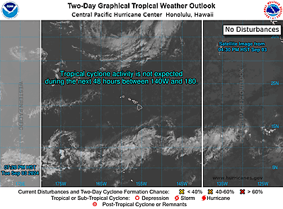
Sat, Jul 20, 2024, Continue reading at the source
Useful links
