Severe weather isn’t out of the ordinary for Tampa Bay. This page collects information from various sources to provide a “situational awareness” into the current weather conditions.
SKYWARN®
The purpose of the SKYWARN® program in Pinellas County Florida is to provide the National Weather Service (NWS) Forecast Office at Tampa Bay with timely and accurate reports of severe weather phenomena so that a timely warning can be issued to the public of dangerous weather conditions that include tornadoes, hail, flooding, and damaging thunderstorm winds.
Detailed information about SKYWARN® operations in Pinellas County can be found in the Pinellas County ACS/ARES® SKYWARN® Operations Plan and Standard Operating Procedures document.
Current Pinellas County Severe Weather Alerts
TEST Tsunami Warning issued April 23 at 12:30PM EDT until April 23 at 1:30PM EDT by NWS National Tsunami Warning Center
from NWS
from NWS
GMZ130-132-135-150-155-230-231-232-235>237-250-255-330-335-
350-355-430-432-435-436-450-452-455-532-534-536-538-550-552-
555-557-630>636-650-655-730-750-752-755-765-830-836-850-853-
856-656-657-031-032-034-035-042>044-052>055-AMZ630-650-651-
550-552-555-450-452-454-330-350-352-354-250-252-254-256-131-
135>137-150>156-158-230-231-ANZ631>638-656-658-650-652-654-
430-431-450>455-331-332-335-338-340-345-350>355-230>237-250-
251-254-255-256-150>154-050>052-TXZ251-256-257-351-354-355-
451-454-455-234-242>247-342>347-442-443-447-214-236>238-313-
335>338-436>439-215-216-615-616-LAZ041-073-074-052>054-241-
252>254-066>070-076-078-MSZ086>088-ALZ261>266-FLZ201>206-008-
010-012-014-108-112>118-127-128-134-139-142-148-149-050-151-
155-160-162-165-069-075-076>078-174-074-154-168-172-173-347-
447-647-747-047-054-059-064-141-147-159-164-024-124-125-133-
138-GAZ153-154-165-166-117-119-139-141-SCZ048>052-054-056-
NCZ106-108-110-044>047-080-081-092>095-098-103-104-193>199-
203>205-015>017-030>032-102-VAZ084>096-098-523>525-099-100-
MDZ024-025-DEZ002>004-NJZ006-012>014-020>027-106-108-NYZ071>075-
078>081-176>179-CTZ009>012-RIZ002-004>008-MAZ007-014>016-019>024-
NHZ014-MEZ022>028-029-030-NBZ570-550-660-641-NSZ210-230-260-
250-110-120-130-170-160-150-140-270-280-320-410-450-440-430-
QCZ670-680-NLZ340-220-230-210-120-132-140-241-242-110-131-
540-530-570-520-510-560-610-720-710-730-740-750-760-770-231730-
/T.NEW.PAAQ.TS.W.9009.240423T1630Z-240423T1730Z/
The U.S. east coast, Gulf of Mexico coasts, and Eastern
Canadian coastal areas
...THIS_MESSAGE_IS_FOR_TEST_PURPOSES_ONLY...
...THIS IS A TEST TO DETERMINE TRANSMISSION TIMES INVOLVED IN THE
DISSEMINATION OF TSUNAMI INFORMATION...
...ESTO ES UNA PRUEBA PARA DETERMINAR LOS TIEMPOS DE TRANSMISION
ENVUELTOS EN LA DISEMINACION DE INFORMACION SOBRE TSUNAMIS...
RESPONSES ARE REQUIRED FROM
---------------------------
* All Coastal Weather Forecast Offices in [...]
Tue, Apr 23, 2024, Continue reading at the source
Please be sure to check the NWS Tampa Bay Graphical Hazardous Weather Outlook daily. It’s an extremely useful to check daily. It presents a graphical view of likelihood of various types of severe weather. If you have a weather radio, Pinellas is covered by two transmitters and Pinellas has a “Specific Area Message Encoding” (SAME code) of 012103.
- Largo Marine – 162.450 MHz
- Tampa Bay – 162.550 MHz
National Weather Service Storm Prediction Center’s Latest Content
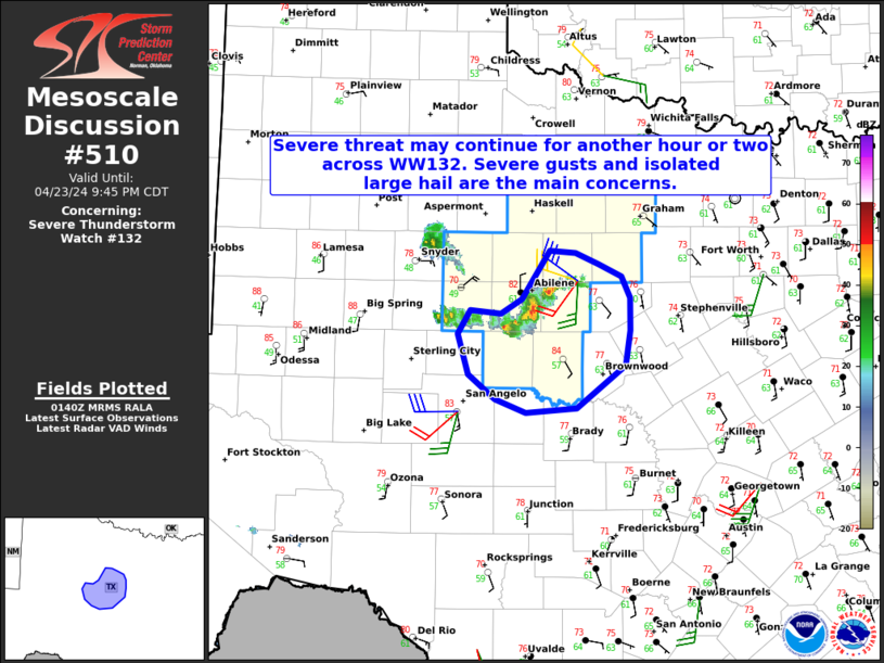
MD 0510 CONCERNING SEVERE THUNDERSTORM WATCH 132... FOR PORTIONS OF NORTHWEST INTO CENTRAL TEXAS
Mesoscale Discussion 0510
NWS Storm Prediction Center Norman OK
0842 PM CDT Tue Apr 23 2024
Areas affected...Portions of Northwest into Central Texas
Concerning...Severe Thunderstorm Watch 132...
Valid 240142Z - 240245Z
The severe weather threat [...]
Tue, Apr 23, 2024, Continue reading at the source
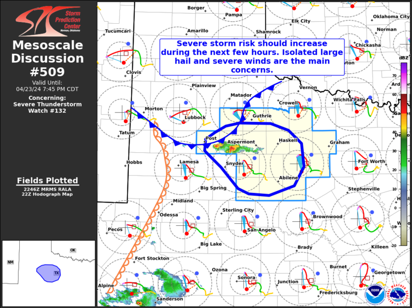
MD 0509 CONCERNING SEVERE THUNDERSTORM WATCH 132... FOR PORTIONS OF NORTHWEST TEXAS
Mesoscale Discussion 0509
NWS Storm Prediction Center Norman OK
0549 PM CDT Tue Apr 23 2024
Areas affected...Portions of Northwest Texas
Concerning...Severe Thunderstorm Watch 132...
Valid 232249Z - 240045Z
The severe weather threat for Severe Thunderstorm Watch [...]
Tue, Apr 23, 2024, Continue reading at the source
WW 0132 Status Updates
STATUS FOR WATCH 0132 HAS NOT BEEN ISSUED YET
[...]
Tue, Apr 23, 2024, Continue reading at the source
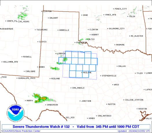
WW 132 SEVERE TSTM TX 232045Z - 240300Z
URGENT - IMMEDIATE BROADCAST REQUESTED
Severe Thunderstorm Watch Number 132
NWS Storm Prediction Center Norman OK
345 PM CDT Tue Apr 23 2024
The NWS Storm Prediction Center has issued a
* Severe Thunderstorm Watch for portions of
Northwest Texas
* [...]
Tue, Apr 23, 2024, Continue reading at the source
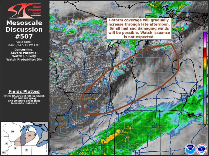
MD 0507 CONCERNING SEVERE POTENTIAL...WATCH UNLIKELY FOR NORTHEAST ILLINOIS AND SOUTHEAST WISCONSIN INTO CENTRAL LOWER MICHIGAN
Mesoscale Discussion 0507
NWS Storm Prediction Center Norman OK
0252 PM CDT Tue Apr 23 2024
Areas affected...Northeast Illinois and southeast Wisconsin into
central Lower Michigan
Concerning...Severe potential...Watch unlikely
Valid 231952Z - [...]
Tue, Apr 23, 2024, Continue reading at the source
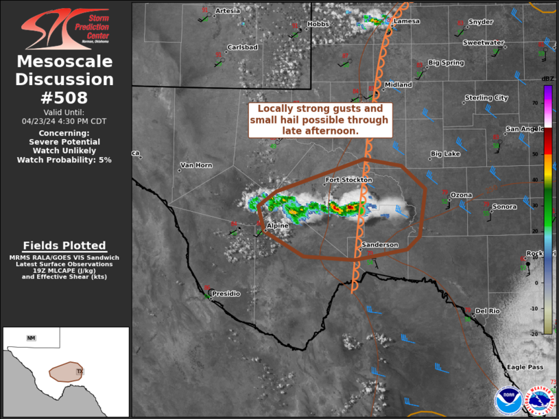
MD 0508 CONCERNING SEVERE POTENTIAL...WATCH UNLIKELY FOR TRANS-PECOS/LOWER PECOS VALLEY OF TX
Mesoscale Discussion 0508
NWS Storm Prediction Center Norman OK
0256 PM CDT Tue Apr 23 2024
Areas affected...Trans-Pecos/Lower Pecos Valley of TX
Concerning...Severe potential...Watch unlikely
Valid 231956Z - 232130Z
Probability of Watch Issuance...5 percent
SUMMARY...Localized strong to [...]
Tue, Apr 23, 2024, Continue reading at the source
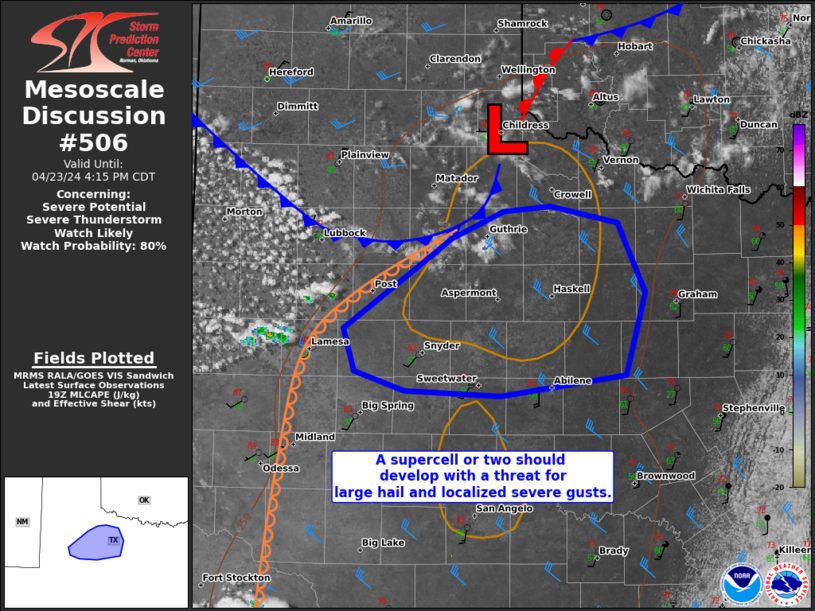
MD 0506 CONCERNING SEVERE POTENTIAL...SEVERE THUNDERSTORM WATCH LIKELY FOR WESTERN NORTH TO BIG COUNTRY OF TX
Mesoscale Discussion 0506
NWS Storm Prediction Center Norman OK
0239 PM CDT Tue Apr 23 2024
Areas affected...western North to Big Country of TX
Concerning...Severe potential...Severe Thunderstorm Watch likely
Valid 231939Z [...]
Tue, Apr 23, 2024, Continue reading at the source
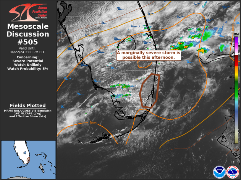
MD 0505 CONCERNING SEVERE POTENTIAL...WATCH UNLIKELY FOR FAR SOUTHEAST FL
Mesoscale Discussion 0505
NWS Storm Prediction Center Norman OK
1123 AM CDT Mon Apr 22 2024
Areas affected...Far southeast FL
Concerning...Severe potential...Watch unlikely
Valid 221623Z - 221800Z
Probability of Watch Issuance...5 percent
SUMMARY...A marginally severe storm with hail up [...]
Mon, Apr 22, 2024, Continue reading at the source
SPC 0600Z Day 2 Outlook
Day 2 Convective Outlook
NWS Storm Prediction Center Norman OK
1244 AM CDT Mon Apr 22 2024
Valid 231200Z - 241200Z
...THERE IS A MARGINAL RISK OF SEVERE THUNDERSTORMS ACROSS PARTS OF
THE SOUTHERN PLAINS...
...SUMMARY...
Isolated severe thunderstorms will be possible on Tuesday from [...]
Mon, Apr 22, 2024, Continue reading at the source
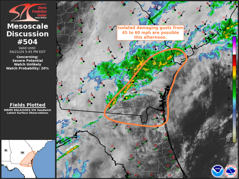
MD 0504 CONCERNING SEVERE POTENTIAL...WATCH UNLIKELY FOR SOUTHEAST GA...FAR NORTHEAST FL
Mesoscale Discussion 0504
NWS Storm Prediction Center Norman OK
0245 PM CDT Sun Apr 21 2024
Areas affected...Southeast GA...Far Northeast FL
Concerning...Severe potential...Watch unlikely
Valid 211945Z - 212145Z
Probability of Watch Issuance...20 percent
SUMMARY...Ongoing convective line may produce [...]
Sun, Apr 21, 2024, Continue reading at the source

