Severe weather isn’t out of the ordinary for Tampa Bay. This page collects information from various sources to provide a “situational awareness” into the current weather conditions.
SKYWARN®
The purpose of the SKYWARN® program in Pinellas County Florida is to provide the National Weather Service (NWS) Forecast Office at Tampa Bay with timely and accurate reports of severe weather phenomena so that a timely warning can be issued to the public of dangerous weather conditions that include tornadoes, hail, flooding, and damaging thunderstorm winds.
Detailed information about SKYWARN® operations in Pinellas County can be found in the Pinellas County ACS/ARES® SKYWARN® Operations Plan and Standard Operating Procedures document.
Current Pinellas County Severe Weather Alerts
Rip Current Statement issued April 13 at 3:25AM EDT until April 13 at 8:00PM EDT by NWS Tampa Bay Ruskin FL
from NWS
from NWS
* WHAT...Dangerous rip currents.
* WHERE...Pinellas, Coastal Hillsborough, Coastal Manatee,
Coastal Sarasota, Coastal Charlotte and Coastal Lee Counties.
* WHEN...Through this evening.
* IMPACTS...Rip currents can sweep even the best swimmers away
from shore into deeper water. [...]
Sat, Apr 13, 2024, Continue reading at the source
Rip Current Statement issued April 12 at 8:10PM EDT until April 13 at 8:00PM EDT by NWS Tampa Bay Ruskin FL
from NWS
from NWS
* WHAT...Dangerous rip currents.
* WHERE...Pinellas, Coastal Hillsborough, Coastal Manatee,
Coastal Sarasota, Coastal Charlotte and Coastal Lee Counties.
* WHEN...Through Saturday evening.
* IMPACTS...Rip currents can sweep even the best swimmers away
from shore into deeper water. [...]
Fri, Apr 12, 2024, Continue reading at the source
High Surf Advisory issued April 12 at 2:51PM EDT until April 12 at 8:00PM EDT by NWS Tampa Bay Ruskin FL
from NWS
from NWS
* WHAT...For the High Rip Current Risk, dangerous rip currents.
For the High Surf Advisory, large breaking waves of 5 feet or
larger.
* WHERE...Pinellas, Coastal Hillsborough, Coastal Manatee,
Coastal Sarasota, Coastal Charlotte and Coastal Lee Counties.
* WHEN...For the High Rip Current Risk, through Saturday
evening. For the High Surf Advisory, until 8 PM EDT [...]
Fri, Apr 12, 2024, Continue reading at the source
Rip Current Statement issued April 12 at 2:51PM EDT until April 13 at 8:00PM EDT by NWS Tampa Bay Ruskin FL
from NWS
from NWS
* WHAT...For the High Rip Current Risk, dangerous rip currents.
For the High Surf Advisory, large breaking waves of 5 feet or
larger.
* WHERE...Pinellas, Coastal Hillsborough, Coastal Manatee,
Coastal Sarasota, Coastal Charlotte and Coastal Lee Counties.
* WHEN...For the High Rip Current Risk, through Saturday
evening. For the High Surf Advisory, until 8 PM EDT [...]
Fri, Apr 12, 2024, Continue reading at the source
High Surf Advisory issued April 12 at 3:40AM EDT until April 12 at 8:00PM EDT by NWS Tampa Bay Ruskin FL
from NWS
from NWS
* WHAT...For the High Rip Current Risk, dangerous rip currents.
For the High Surf Advisory, large breaking waves of 5 feet or
larger.
* WHERE...Pinellas, Coastal Hillsborough, Coastal Manatee,
Coastal Sarasota, Coastal Charlotte and Coastal Lee Counties.
* WHEN...For the High Rip Current Risk, through Saturday
evening. For the High Surf Advisory, until 8 PM EDT [...]
Fri, Apr 12, 2024, Continue reading at the source
Rip Current Statement issued April 12 at 3:40AM EDT until April 13 at 8:00PM EDT by NWS Tampa Bay Ruskin FL
from NWS
from NWS
* WHAT...For the High Rip Current Risk, dangerous rip currents.
For the High Surf Advisory, large breaking waves of 5 feet or
larger.
* WHERE...Pinellas, Coastal Hillsborough, Coastal Manatee,
Coastal Sarasota, Coastal Charlotte and Coastal Lee Counties.
* WHEN...For the High Rip Current Risk, through Saturday
evening. For the High Surf Advisory, until 8 PM EDT [...]
Fri, Apr 12, 2024, Continue reading at the source
Please be sure to check the NWS Tampa Bay Graphical Hazardous Weather Outlook daily. It’s an extremely useful to check daily. It presents a graphical view of likelihood of various types of severe weather. If you have a weather radio, Pinellas is covered by two transmitters and Pinellas has a “Specific Area Message Encoding” (SAME code) of 012103.
- Largo Marine – 162.450 MHz
- Tampa Bay – 162.550 MHz
National Weather Service Storm Prediction Center’s Latest Content
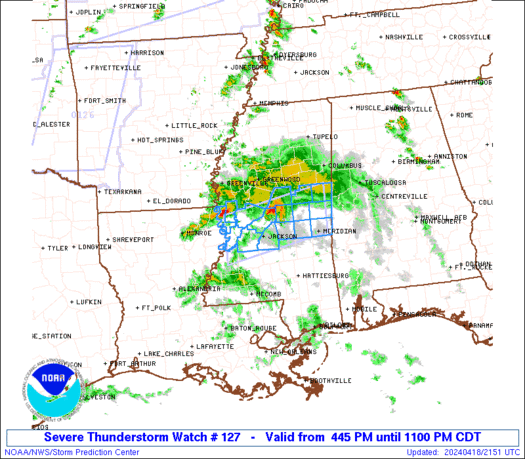
WW 0127 Status Updates
STATUS FOR WATCH 0127 HAS NOT BEEN ISSUED YET
[...]
Thu, Apr 18, 2024, Continue reading at the source
WW 127 SEVERE TSTM MS 182145Z - 190400Z
URGENT - IMMEDIATE BROADCAST REQUESTED
Severe Thunderstorm Watch Number 127
NWS Storm Prediction Center Norman OK
445 PM CDT Thu Apr 18 2024
The NWS Storm Prediction Center has issued a
* Severe Thunderstorm Watch for portions of
Central Mississippi
* [...]
Thu, Apr 18, 2024, Continue reading at the source
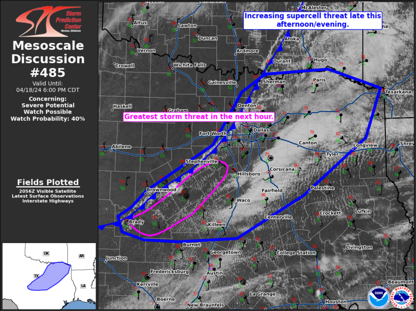
MD 0485 CONCERNING SEVERE POTENTIAL...WATCH POSSIBLE FOR CENTRAL/NORTH-CENTRAL INTO NORTHEAST TEXAS
Mesoscale Discussion 0485
NWS Storm Prediction Center Norman OK
0402 PM CDT Thu Apr 18 2024
Areas affected...central/north-central into northeast Texas
Concerning...Severe potential...Watch possible
Valid 182102Z - 182300Z
Probability of Watch Issuance...40 percent
SUMMARY...The threat for isolated to [...]
Thu, Apr 18, 2024, Continue reading at the source
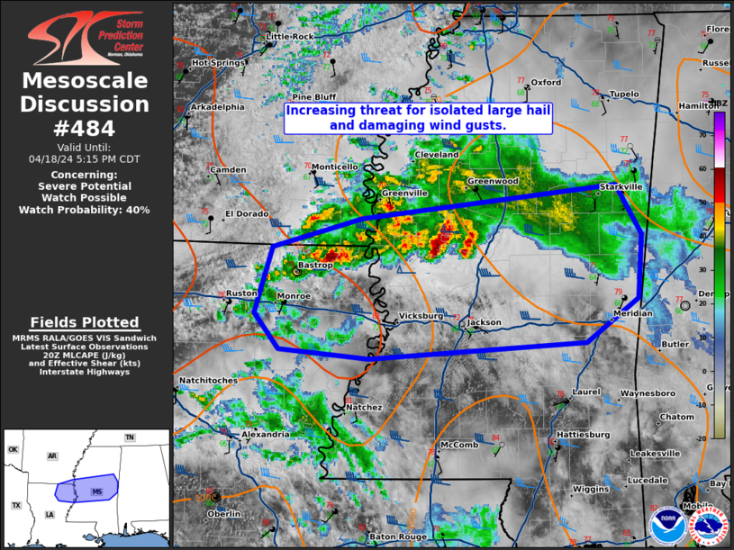
MD 0484 CONCERNING SEVERE POTENTIAL...WATCH POSSIBLE FOR NORTHEAST LOUISIANA AND CENTRAL MISSISSIPPI
Mesoscale Discussion 0484
NWS Storm Prediction Center Norman OK
0339 PM CDT Thu Apr 18 2024
Areas affected...northeast Louisiana and central Mississippi
Concerning...Severe potential...Watch possible
Valid 182039Z - 182215Z
Probability of Watch Issuance...40 percent
SUMMARY...The threat for [...]
Thu, Apr 18, 2024, Continue reading at the source
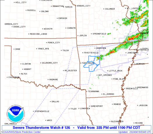
WW 0126 Status Updates
STATUS FOR WATCH 0126 HAS NOT BEEN ISSUED YET
[...]
Thu, Apr 18, 2024, Continue reading at the source
WW 126 SEVERE TSTM AR OK 182035Z - 190400Z
URGENT - IMMEDIATE BROADCAST REQUESTED
Severe Thunderstorm Watch Number 126
NWS Storm Prediction Center Norman OK
335 PM CDT Thu Apr 18 2024
The NWS Storm Prediction Center has issued a
* Severe Thunderstorm Watch for portions of
Western [...]
Thu, Apr 18, 2024, Continue reading at the source
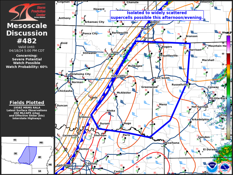
MD 0482 CONCERNING SEVERE POTENTIAL...WATCH POSSIBLE FOR EASTERN OKLAHOMA AND WESTERN ARKANSAS
Mesoscale Discussion 0482
NWS Storm Prediction Center Norman OK
0301 PM CDT Thu Apr 18 2024
Areas affected...eastern Oklahoma and western Arkansas
Concerning...Severe potential...Watch possible
Valid 182001Z - 182200Z
Probability of Watch Issuance...60 percent
SUMMARY...Isolated to widely [...]
Thu, Apr 18, 2024, Continue reading at the source
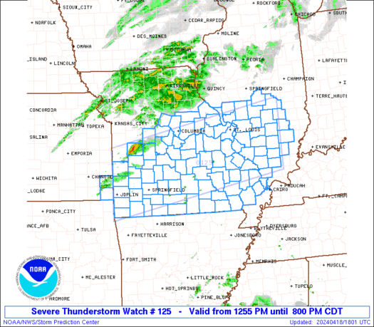
MD 0483 CONCERNING SEVERE THUNDERSTORM WATCH 125... FOR CENTRAL AND SOUTHERN MISSOURI INTO SOUTHERN AND CENTRAL ILLINOIS
Mesoscale Discussion 0483
NWS Storm Prediction Center Norman OK
0309 PM CDT Thu Apr 18 2024
Areas affected...central and southern Missouri into southern and
central Illinois
Concerning...Severe Thunderstorm Watch 125...
Valid 182009Z [...]
Thu, Apr 18, 2024, Continue reading at the source
SPC 2000Z Day 1 Outlook
Day 1 Convective Outlook
NWS Storm Prediction Center Norman OK
0253 PM CDT Thu Apr 18 2024
Valid 182000Z - 191200Z
...THERE IS AN ENHANCED RISK OF SEVERE THUNDERSTORMS FOR PORTIONS OF
EASTERN MISSOURI INTO SOUTHERN ILLINOIS...EXTREME SOUTHWEST
INDIANA...FAR SOUTHWESTERN KENTUCKY...FAR NORTHWESTERN TENNESSEE...
...SUMMARY...
Damaging gusts [...]
Thu, Apr 18, 2024, Continue reading at the source
WW 0125 Status Updates
STATUS FOR WATCH 0125 HAS NOT BEEN ISSUED YET
[...]
Thu, Apr 18, 2024, Continue reading at the source

