Severe weather isn’t out of the ordinary for Tampa Bay. This page collects information from various sources to provide a “situational awareness” into the current weather conditions.
SKYWARN®
The purpose of the SKYWARN® program in Pinellas County Florida is to provide the National Weather Service (NWS) Forecast Office at Tampa Bay with timely and accurate reports of severe weather phenomena so that a timely warning can be issued to the public of dangerous weather conditions that include tornadoes, hail, flooding, and damaging thunderstorm winds.
Detailed information about SKYWARN® operations in Pinellas County can be found in the Pinellas County ACS/ARES® SKYWARN® Operations Plan and Standard Operating Procedures document.
Current Pinellas County Severe Weather Alerts
Rip Current Statement issued April 13 at 3:25AM EDT until April 13 at 8:00PM EDT by NWS Tampa Bay Ruskin FL
from NWS
from NWS
* WHAT...Dangerous rip currents.
* WHERE...Pinellas, Coastal Hillsborough, Coastal Manatee,
Coastal Sarasota, Coastal Charlotte and Coastal Lee Counties.
* WHEN...Through this evening.
* IMPACTS...Rip currents can sweep even the best swimmers away
from shore into deeper water. [...]
Sat, Apr 13, 2024, Continue reading at the source
Rip Current Statement issued April 12 at 8:10PM EDT until April 13 at 8:00PM EDT by NWS Tampa Bay Ruskin FL
from NWS
from NWS
* WHAT...Dangerous rip currents.
* WHERE...Pinellas, Coastal Hillsborough, Coastal Manatee,
Coastal Sarasota, Coastal Charlotte and Coastal Lee Counties.
* WHEN...Through Saturday evening.
* IMPACTS...Rip currents can sweep even the best swimmers away
from shore into deeper water. [...]
Fri, Apr 12, 2024, Continue reading at the source
High Surf Advisory issued April 12 at 2:51PM EDT until April 12 at 8:00PM EDT by NWS Tampa Bay Ruskin FL
from NWS
from NWS
* WHAT...For the High Rip Current Risk, dangerous rip currents.
For the High Surf Advisory, large breaking waves of 5 feet or
larger.
* WHERE...Pinellas, Coastal Hillsborough, Coastal Manatee,
Coastal Sarasota, Coastal Charlotte and Coastal Lee Counties.
* WHEN...For the High Rip Current Risk, through Saturday
evening. For the High Surf Advisory, until 8 PM EDT [...]
Fri, Apr 12, 2024, Continue reading at the source
Rip Current Statement issued April 12 at 2:51PM EDT until April 13 at 8:00PM EDT by NWS Tampa Bay Ruskin FL
from NWS
from NWS
* WHAT...For the High Rip Current Risk, dangerous rip currents.
For the High Surf Advisory, large breaking waves of 5 feet or
larger.
* WHERE...Pinellas, Coastal Hillsborough, Coastal Manatee,
Coastal Sarasota, Coastal Charlotte and Coastal Lee Counties.
* WHEN...For the High Rip Current Risk, through Saturday
evening. For the High Surf Advisory, until 8 PM EDT [...]
Fri, Apr 12, 2024, Continue reading at the source
High Surf Advisory issued April 12 at 3:40AM EDT until April 12 at 8:00PM EDT by NWS Tampa Bay Ruskin FL
from NWS
from NWS
* WHAT...For the High Rip Current Risk, dangerous rip currents.
For the High Surf Advisory, large breaking waves of 5 feet or
larger.
* WHERE...Pinellas, Coastal Hillsborough, Coastal Manatee,
Coastal Sarasota, Coastal Charlotte and Coastal Lee Counties.
* WHEN...For the High Rip Current Risk, through Saturday
evening. For the High Surf Advisory, until 8 PM EDT [...]
Fri, Apr 12, 2024, Continue reading at the source
Rip Current Statement issued April 12 at 3:40AM EDT until April 13 at 8:00PM EDT by NWS Tampa Bay Ruskin FL
from NWS
from NWS
* WHAT...For the High Rip Current Risk, dangerous rip currents.
For the High Surf Advisory, large breaking waves of 5 feet or
larger.
* WHERE...Pinellas, Coastal Hillsborough, Coastal Manatee,
Coastal Sarasota, Coastal Charlotte and Coastal Lee Counties.
* WHEN...For the High Rip Current Risk, through Saturday
evening. For the High Surf Advisory, until 8 PM EDT [...]
Fri, Apr 12, 2024, Continue reading at the source
Severe Thunderstorm Warning issued April 11 at 1:16PM EDT until April 11 at 2:00PM EDT by NWS Tampa Bay Ruskin FL
from NWS
from NWS
SVRTBW
The National Weather Service in Ruskin has issued a
* Severe Thunderstorm Warning for...
Southeastern Pasco County in west central Florida...
Manatee County in west central Florida...
Southeastern Pinellas County in west central Florida...
Northwestern Polk County in central Florida...
Hillsborough County in west central Florida...
* Until 200 PM EDT.
* At 116 PM EDT, severe thunderstorms [...]
Thu, Apr 11, 2024, Continue reading at the source
Severe Thunderstorm Warning issued April 11 at 12:30PM EDT until April 11 at 1:15PM EDT by NWS Tampa Bay Ruskin FL
from NWS
from NWS
SVRTBW
The National Weather Service in Ruskin has issued a
* Severe Thunderstorm Warning for...
Southeastern Citrus County in west central Florida...
Sumter County in central Florida...
Pasco County in west central Florida...
Hernando County in west central Florida...
Northwestern Manatee County in west central Florida...
Pinellas County in west central Florida...
Northwestern Polk County in central Florida...
Hillsborough County [...]
Thu, Apr 11, 2024, Continue reading at the source
Tornado Warning issued April 11 at 12:16PM EDT until April 11 at 12:45PM EDT by NWS Tampa Bay Ruskin FL
from NWS
from NWS
TORTBW
The National Weather Service in Ruskin has issued a
* Tornado Warning for...
Northwestern Pinellas County in west central Florida...
* Until 1245 PM EDT.
* At 1215 PM EDT, a severe thunderstorm capable of producing a
tornado was located near Harbor Bluffs, or 7 miles northwest of
Seminole, moving northeast at 35 mph.
HAZARD...Tornado.
SOURCE...Radar indicated rotation.
IMPACT...Flying [...]
Thu, Apr 11, 2024, Continue reading at the source
Tornado Watch issued April 11 at 12:05PM EDT until April 11 at 3:00PM EDT by NWS Tampa Bay Ruskin FL
from NWS
from NWS
TORNADO WATCH 104 REMAINS VALID UNTIL 3 PM EDT THIS AFTERNOON FOR
THE FOLLOWING AREAS
IN FLORIDA THIS WATCH INCLUDES 7 COUNTIES
IN CENTRAL FLORIDA
POLK SUMTER
IN WEST CENTRAL FLORIDA
CITRUS [...]
Thu, Apr 11, 2024, Continue reading at the source
Please be sure to check the NWS Tampa Bay Graphical Hazardous Weather Outlook daily. It’s an extremely useful to check daily. It presents a graphical view of likelihood of various types of severe weather. If you have a weather radio, Pinellas is covered by two transmitters and Pinellas has a “Specific Area Message Encoding” (SAME code) of 012103.
- Largo Marine – 162.450 MHz
- Tampa Bay – 162.550 MHz
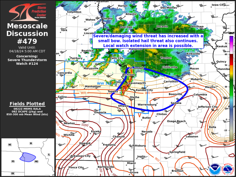
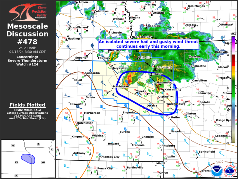
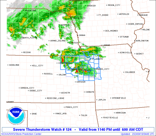
National Weather Service Storm Prediction Center’s Latest Content
Thu, Apr 18, 2024, Continue reading at the source
Thu, Apr 18, 2024, Continue reading at the source

Thu, Apr 18, 2024, Continue reading at the source
Thu, Apr 18, 2024, Continue reading at the source
Thu, Apr 18, 2024, Continue reading at the source
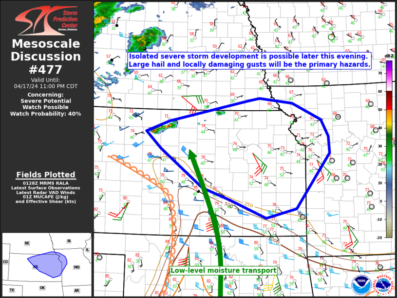
Wed, Apr 17, 2024, Continue reading at the source
Wed, Apr 17, 2024, Continue reading at the source
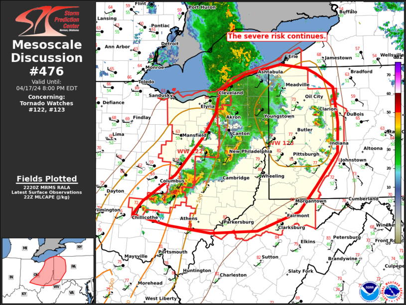
Wed, Apr 17, 2024, Continue reading at the source

Wed, Apr 17, 2024, Continue reading at the source
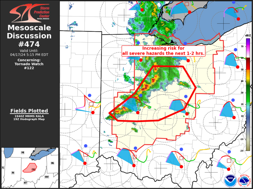
Wed, Apr 17, 2024, Continue reading at the source
National Hurricane Center’s Tropical Weather Outlook
The Central North Pacific hurricane season runs from June 1st through November 30th. [...]
Wed, Dec 06, 2023, Continue reading at the source
The Eastern North Pacific hurricane season runs from May 15th through November 30th. [...]
Sat, Dec 02, 2023, Continue reading at the source
The Atlantic hurricane season runs from June 1st through November 30th. [...]
Sat, Dec 02, 2023, Continue reading at the source
Useful links
