Severe weather isn’t out of the ordinary for Tampa Bay. This page collects information from various sources to provide a “situational awareness” into the current weather conditions.
SKYWARN®
The purpose of the SKYWARN® program in Pinellas County Florida is to provide the National Weather Service (NWS) Forecast Office at Tampa Bay with timely and accurate reports of severe weather phenomena so that a timely warning can be issued to the public of dangerous weather conditions that include tornadoes, hail, flooding, and damaging thunderstorm winds.
Detailed information about SKYWARN® operations in Pinellas County can be found in the Pinellas County ACS/ARES® SKYWARN® Operations Plan and Standard Operating Procedures document.
Current Pinellas County Severe Weather Alerts
TEST Tsunami Warning issued April 23 at 12:30PM EDT until April 23 at 1:30PM EDT by NWS National Tsunami Warning Center
from NWS
from NWS
GMZ130-132-135-150-155-230-231-232-235>237-250-255-330-335-
350-355-430-432-435-436-450-452-455-532-534-536-538-550-552-
555-557-630>636-650-655-730-750-752-755-765-830-836-850-853-
856-656-657-031-032-034-035-042>044-052>055-AMZ630-650-651-
550-552-555-450-452-454-330-350-352-354-250-252-254-256-131-
135>137-150>156-158-230-231-ANZ631>638-656-658-650-652-654-
430-431-450>455-331-332-335-338-340-345-350>355-230>237-250-
251-254-255-256-150>154-050>052-TXZ251-256-257-351-354-355-
451-454-455-234-242>247-342>347-442-443-447-214-236>238-313-
335>338-436>439-215-216-615-616-LAZ041-073-074-052>054-241-
252>254-066>070-076-078-MSZ086>088-ALZ261>266-FLZ201>206-008-
010-012-014-108-112>118-127-128-134-139-142-148-149-050-151-
155-160-162-165-069-075-076>078-174-074-154-168-172-173-347-
447-647-747-047-054-059-064-141-147-159-164-024-124-125-133-
138-GAZ153-154-165-166-117-119-139-141-SCZ048>052-054-056-
NCZ106-108-110-044>047-080-081-092>095-098-103-104-193>199-
203>205-015>017-030>032-102-VAZ084>096-098-523>525-099-100-
MDZ024-025-DEZ002>004-NJZ006-012>014-020>027-106-108-NYZ071>075-
078>081-176>179-CTZ009>012-RIZ002-004>008-MAZ007-014>016-019>024-
NHZ014-MEZ022>028-029-030-NBZ570-550-660-641-NSZ210-230-260-
250-110-120-130-170-160-150-140-270-280-320-410-450-440-430-
QCZ670-680-NLZ340-220-230-210-120-132-140-241-242-110-131-
540-530-570-520-510-560-610-720-710-730-740-750-760-770-231730-
/T.NEW.PAAQ.TS.W.9009.240423T1630Z-240423T1730Z/
The U.S. east coast, Gulf of Mexico coasts, and Eastern
Canadian coastal areas
...THIS_MESSAGE_IS_FOR_TEST_PURPOSES_ONLY...
...THIS IS A TEST TO DETERMINE TRANSMISSION TIMES INVOLVED IN THE
DISSEMINATION OF TSUNAMI INFORMATION...
...ESTO ES UNA PRUEBA PARA DETERMINAR LOS TIEMPOS DE TRANSMISION
ENVUELTOS EN LA DISEMINACION DE INFORMACION SOBRE TSUNAMIS...
RESPONSES ARE REQUIRED FROM
---------------------------
* All Coastal Weather Forecast Offices in [...]
Tue, Apr 23, 2024, Continue reading at the source
Please be sure to check the NWS Tampa Bay Graphical Hazardous Weather Outlook daily. It’s an extremely useful to check daily. It presents a graphical view of likelihood of various types of severe weather. If you have a weather radio, Pinellas is covered by two transmitters and Pinellas has a “Specific Area Message Encoding” (SAME code) of 012103.
- Largo Marine – 162.450 MHz
- Tampa Bay – 162.550 MHz
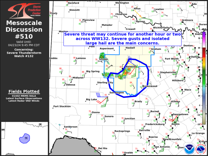
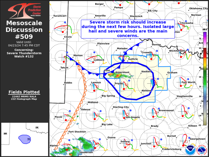
National Weather Service Storm Prediction Center’s Latest Content

Wed, Apr 24, 2024, Continue reading at the source

Wed, Apr 24, 2024, Continue reading at the source

Wed, Apr 24, 2024, Continue reading at the source

Wed, Apr 24, 2024, Continue reading at the source

Wed, Apr 24, 2024, Continue reading at the source
Wed, Apr 24, 2024, Continue reading at the source
Tue, Apr 23, 2024, Continue reading at the source
Tue, Apr 23, 2024, Continue reading at the source
Tue, Apr 23, 2024, Continue reading at the source
Tue, Apr 23, 2024, Continue reading at the source
National Hurricane Center’s Tropical Weather Outlook

Wed, Apr 24, 2024, Continue reading at the source
Useful links
