Severe Weather

Severe weather isn’t out of the ordinary for Tampa Bay. This page collects information from various sources to provide a “situational awareness” into the current weather conditions.

SKYWARN®

The purpose of the SKYWARN® program in Pinellas County Florida is to provide the National Weather Service (NWS) Forecast Office at Tampa Bay with timely and accurate reports of severe weather phenomena so that a timely warning can be issued to the public of dangerous weather conditions that include tornadoes, hail, flooding, and damaging thunderstorm winds.

Detailed information about SKYWARN® operations in Pinellas County can be found in the Pinellas County ACS/ARES® SKYWARN® Operations Plan and Standard Operating Procedures document.

Current Pinellas County Severe Weather Alerts


Please be sure to check the NWS Tampa Bay Graphical Hazardous Weather Outlook daily. It’s an extremely useful to check daily. It presents a graphical view of likelihood of various types of severe weather. If you have a weather radio, Pinellas is covered by two transmitters and Pinellas has a “Specific Area Message Encoding” (SAME code) of 012103.

  • Largo Marine – 162.450 MHz
  • Tampa Bay – 162.550 MHz

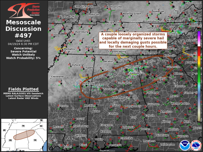
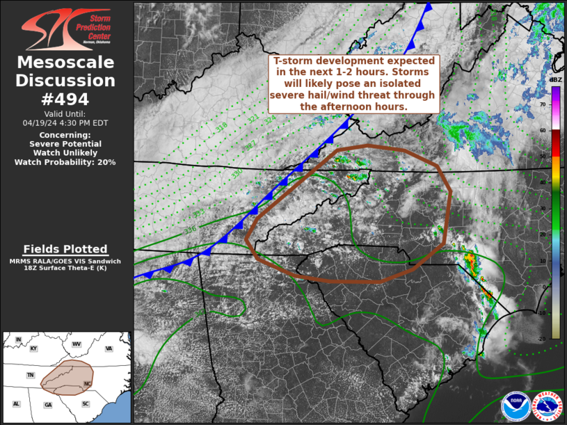
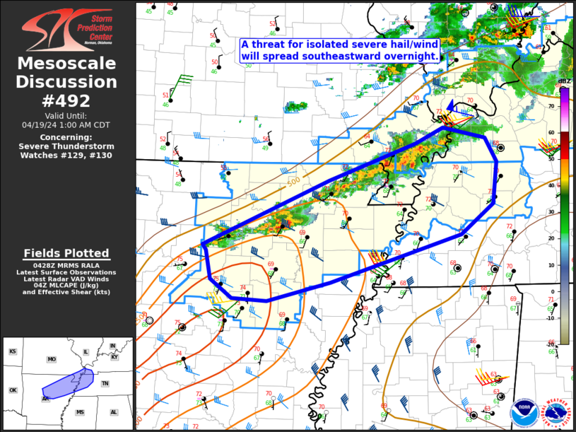
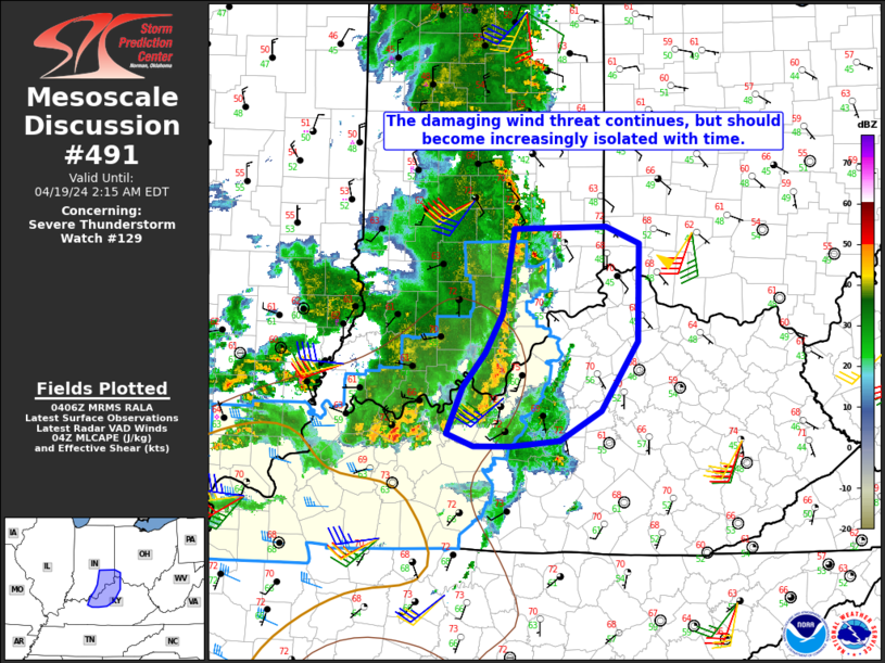
National Weather Service Storm Prediction Center’s Latest Content

Day 4-8 Outlook Image
Day 4-8 Outlook Day 4-8 Convective Outlook NWS Storm Prediction Center Norman OK 0359 AM CDT Sat Apr 20 2024 Valid 231200Z - 281200Z ...DISCUSSION... ...Tuesday/Day 4 and Wednesday/Day 5... An upper-level ridge is forecast to move eastward from the Intermountain West on Tuesday into the Rockies on Wednesday. At [...]
Sat, Apr 20, 2024, Continue reading at the source
MD 0497 Image
MD 0497 CONCERNING SEVERE POTENTIAL...WATCH UNLIKELY FOR PORTIONS OF FAR EAST-CENTRAL MS...NORTHERN/CENTRAL AL...AND NORTHERN GA Mesoscale Discussion 0497 NWS Storm Prediction Center Norman OK 0454 PM CDT Fri Apr 19 2024 Areas affected...Portions of far east-central MS...northern/central AL...and northern GA Concerning...Severe potential...Watch unlikely Valid 192154Z - 192330Z Probability of [...]
Fri, Apr 19, 2024, Continue reading at the source
MD 0494 Image
MD 0494 CONCERNING SEVERE POTENTIAL...WATCH UNLIKELY FOR PORTIONS OF THE TENNESSEE VALLEY INTO THE MID-ATLANTIC Mesoscale Discussion 0494 NWS Storm Prediction Center Norman OK 0133 PM CDT Fri Apr 19 2024 Areas affected...portions of the Tennessee Valley into the Mid-Atlantic Concerning...Severe potential...Watch unlikely Valid 191833Z - 192030Z Probability of [...]
Fri, Apr 19, 2024, Continue reading at the source
MD 0493 Image
MD 0493 CONCERNING SEVERE POTENTIAL...WATCH UNLIKELY FOR EASTERN SOUTH CAROLINA INTO FAR SOUTHEAST NORTH CAROLINA Mesoscale Discussion 0493 NWS Storm Prediction Center Norman OK 1207 PM CDT Fri Apr 19 2024 Areas affected...Eastern South Carolina into far southeast North Carolina Concerning...Severe potential...Watch unlikely Valid 191707Z - 191900Z Probability of [...]
Fri, Apr 19, 2024, Continue reading at the source
MD 0492 Image
MD 0492 CONCERNING SEVERE THUNDERSTORM WATCH 129...130... FOR NORTH-CENTRAL/NORTHEAST AR INTO SOUTHEAST MO...WESTERN TN...FAR WESTERN KY Mesoscale Discussion 0492 NWS Storm Prediction Center Norman OK 1130 PM CDT Thu Apr 18 2024 Areas affected...North-central/northeast AR into southeast MO...western TN...far western KY Concerning...Severe Thunderstorm Watch 129...130... Valid 190430Z - 190600Z The [...]
Fri, Apr 19, 2024, Continue reading at the source
MD 0491 Image
MD 0491 CONCERNING SEVERE THUNDERSTORM WATCH 129... FOR PARTS OF SOUTHEAST IN...NORTHERN KY...FAR SOUTHWEST OH Mesoscale Discussion 0491 NWS Storm Prediction Center Norman OK 1108 PM CDT Thu Apr 18 2024 Areas affected...Parts of southeast IN...northern KY...far southwest OH Concerning...Severe Thunderstorm Watch 129... Valid 190408Z - 190615Z The severe weather [...]
Fri, Apr 19, 2024, Continue reading at the source
WW 0130 Status Image
WW 0130 Status Updates STATUS FOR WATCH 0130 HAS NOT BEEN ISSUED YET [...]
Thu, Apr 18, 2024, Continue reading at the source
WW 0130 Image
WW 130 SEVERE TSTM AR MO TN 190210Z - 190700Z URGENT - IMMEDIATE BROADCAST REQUESTED Severe Thunderstorm Watch Number 130 NWS Storm Prediction Center Norman OK 910 PM CDT Thu Apr 18 2024 The NWS Storm Prediction Center has issued a * Severe Thunderstorm Watch for portions of [...]
Thu, Apr 18, 2024, Continue reading at the source
MD 0490 Image
MD 0490 CONCERNING SEVERE THUNDERSTORM WATCH 126... FOR EXTREME SOUTHEAST OK INTO MUCH OF AR...WESTERN TN...AND THE MO BOOTHEEL Mesoscale Discussion 0490 NWS Storm Prediction Center Norman OK 0841 PM CDT Thu Apr 18 2024 Areas affected...Extreme southeast OK into much of AR...western TN...and the MO Bootheel Concerning...Severe [...]
Thu, Apr 18, 2024, Continue reading at the source
MD 0489 Image
MD 0489 CONCERNING SEVERE THUNDERSTORM WATCH 128... FOR PORTIONS OF CENTRAL TEXAS Mesoscale Discussion 0489 NWS Storm Prediction Center Norman OK 0637 PM CDT Thu Apr 18 2024 Areas affected...Portions of central Texas Concerning...Severe Thunderstorm Watch 128... Valid 182337Z - 190100Z The severe weather threat for Severe Thunderstorm Watch [...]
Thu, Apr 18, 2024, Continue reading at the source

National Hurricane Center’s Tropical Weather Outlook

The Central North Pacific hurricane season runs from June 1st through November 30th. [...]
Wed, Dec 06, 2023, Continue reading at the source
The Eastern North Pacific hurricane season runs from May 15th through November 30th. [...]
Sat, Dec 02, 2023, Continue reading at the source
The Atlantic hurricane season runs from June 1st through November 30th. [...]
Sat, Dec 02, 2023, Continue reading at the source

Useful links

ACS – Pinellas County:  Pinellas County ACS Home Page
ACS/ARES® aresdb Database: http://www.aresdb.com/
Become a rain observer: http://www.cocoRahs.org
Become an ambassador: http://weather.gov/tampa/wrn
Emergency Managers Weather Information Network — https://www.weather.gov/emwin/ 
Facebook – NWS Tampa Bay: https://www.facebook.com/NWSTampaBay/
Hurricane Guide: http://www.pinellascounty.org/emergency/default.htm#hurricaneguide
Mike’s Weather Page: https://spaghettimodels.com/
National Hurricane Center Amateur Radio Station – WX4NHC:https://w4ehw.fiu.edu/
National Hurricane Center: https://www.nhc.noaa.gov/
National Weather Service: https://www.weather.gov/
NWS Radar: https://radar.weather.gov/
NWS Ruskin SKYWARN® Amateur Radio Station: https://www.weather.gov/tbw/wx4tor
NWS Ruskin SKYWARN® Page: http://weather.gov/tampa/skywarn
Sign up for weather alerts: http://AlertFlorida.com
Storm Prediction Center: https://www.spc.noaa.gov/
Tampa Bay Graphical Hazardous Weather Outlook: https://www.weather.gov/tbw/ghwo
Training – Spotter Network: http://SpotterNetwork.org
Training – MetED: https://www.meted.ucar.edu/education_training/course/23
Tropical Cyclone Guidance Project: http://hurricanes.ral.ucar.edu/realtime/current/
Twitter – NWS Tampa Bay: https://twitter.com/nwstampabay
VoIP SKYWARN®/Hurricane Net: http://voipwx.net/
Weather Spotter’s Field Guide: https://go.usa.gov/xnDYC
Windy.com: https://www.windy.com/
Print Friendly, PDF & Email

Leave a Reply